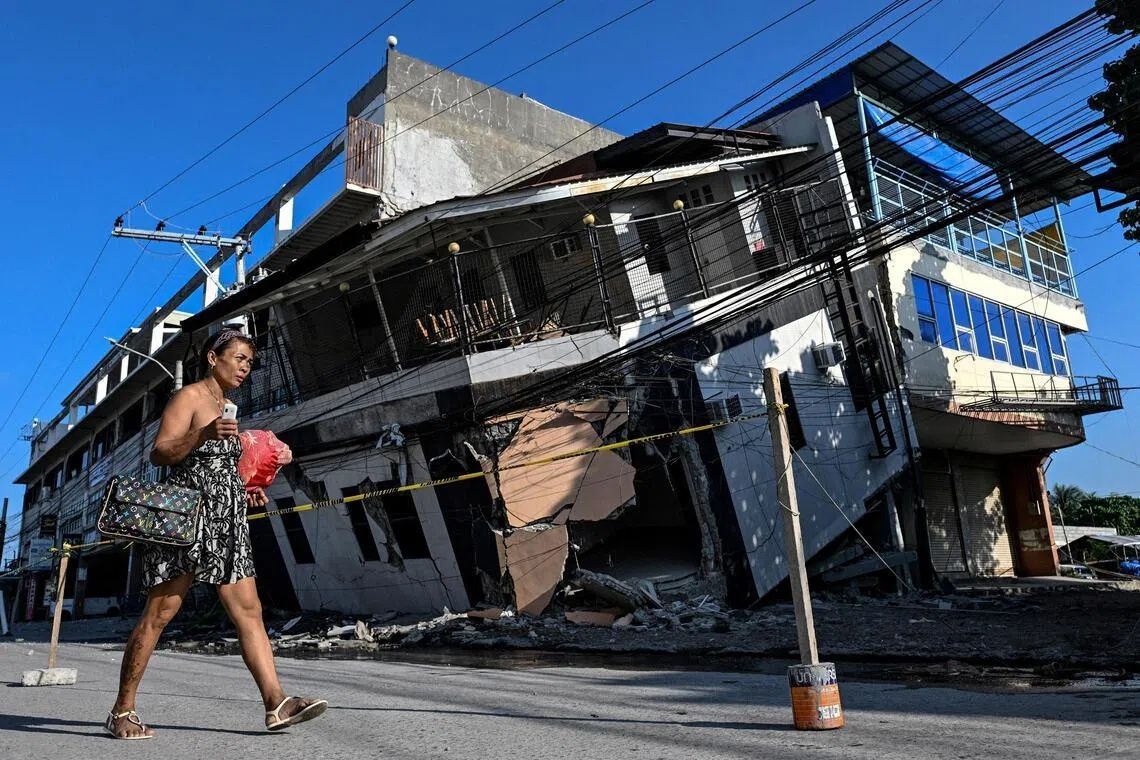
When the ground began to heave beneath his home last week, Arsenio Butil Jr., a fisherman and pastor in Glan, Sarangani province, dropped to his knees in prayer. But what confronted him when he looked up was something far more extraordinary than the terrifying tremor itself: the entire shoreline he had known his entire life was visibly transforming before his eyes. Expanses of coral reef that had remained submerged for centuries suddenly broke the surface of the water, creating a jagged new landscape that would soon extend hundreds of metres further from the original high-water mark. The June 8 earthquake, which measured 7.8 on the magnitude scale, was driven by tectonic movement along the Cotabato Trench and struck with devastating force across the southern island of Mindanao, killing at least 76 people, toppling buildings, and triggering destructive landslides that buried communities under metres of earth and rock.
The phenomenon that reshaped this portion of the Philippine coastline is known to geologists as coastal uplift—a dramatic but natural consequence of the immense forces at work when tectonic plates shift during major earthquakes. For residents who have spent decades or even generations working these waters and living along these shores, the transformation proved deeply disorienting. Fishing vessels that had bobbed at the waterline only days earlier now sat stranded on the wrong side of extensive coral walls that stretched for kilometres in both directions, their hulls exposed to the harsh sun and rendered unusable by the sudden recession of the sea. The change was not merely cosmetic; it represented a fundamental alteration of the physical environment and livelihoods that families depended upon for survival.
Butil Jr. recounted the earthquake as the most violent seismic event he had experienced in his lifetime. The initial shaking was accompanied by a dramatic spectacle at the shoreline that would become a recurring pattern: the water withdrew dramatically from the coast, retreated back toward the normal line, then receded again. This sequence repeated three or four times over the course of the earthquake and its immediate aftermath, each pulse accompanied by the sight of dying fish floating in the shallow waters. The psychological impact on local residents was severe, with widespread panic and terror among people who had never witnessed such a profound disturbance of their world.
The Cotabato Trench, positioned as close as 50 kilometres offshore from Mindanao, sits atop one of the most geologically active zones in Southeast Asia. The region experiences frequent seismic activity, a pattern that intensified in January when thousands of mostly minor tremors formed what scientists call an earthquake swarm. These warning signs were significant enough that a UN disaster risk reduction report issued in mid-May explicitly raised the possibility that such activity could herald a major seismic event—a prediction that proved tragically accurate just weeks later. Understanding the geological context helps explain why this region remains particularly vulnerable to sudden and violent ground displacement.
According to Nane Danlag, a scientist at the Philippines' seismology centre, the permanent elevation of the seabed amounted to approximately two metres, a seemingly modest vertical displacement that nonetheless extended the shoreline seaward by as much as 200 metres in certain locations. The affected coastal zone stretched across nearly 100 kilometres between two towns, demonstrating the vast scale of the transformation. Danlag emphasised that this change represented humanity's new permanent reality along this stretch of coast—the uplift is not temporary and will not reverse. What may appear shocking and unprecedented to residents reflects instead a natural tectonic process that has operated throughout Earth's geological history, one that has been ongoing in this region for thousands of years.
Yet for those displaced by the disaster, the permanence of these changes only deepened their sense of dislocation and vulnerability. Approximately 100 residents, including men, women, and children, remained encamped on higher ground several days after the initial quake when visited by international journalists. Datu Atom Malimpnig, a Maguindanaon community leader and chieftain, explained that the newly formed coastline had left the local fishing families reluctant to return to their devastated homes, even after the most intense shaking subsided. The fundamental alteration of the seabed had implanted in the community's collective consciousness a new fear: that the ocean itself might surge forward without warning, that the precarious balance between land and sea had been disrupted beyond recovery. This psychological barrier, rooted in legitimate uncertainty about future seismic and tsunami hazards, proved as significant as the physical destruction in keeping families displaced.
The economic dimensions of this geological transformation extended beyond the fishing communities themselves. At the Isla Jardin del Mar resort, located about ten kilometres from Glan, the newly exposed coral and transformed coastline threatened a business model entirely dependent on natural beauty and coastal access. Edzel Baylon, a resort staff member, voiced the quiet despair of an enterprise whose primary asset—pristine white sand beaches and inviting waters—had been fundamentally compromised. The sea that once lapped invitingly at the shore now sat so far distant that the shallow, exposed coral formed an impassable barrier, rendering the beachfront unsuitable for the swimming and water activities that guests expected. The economic reverberations of this geological event would likely extend far beyond the immediate period of physical reconstruction.
The seismic activity in the region showed no signs of abating in the days following the principal quake. The Philippine seismology agency recorded more than 8,500 aftershocks, a staggering number of secondary tremors that kept residents in a state of heightened anxiety and prevented meaningful recovery efforts. Each subsequent tremor, however minor, reinforced the sense that the ground beneath people's feet had become fundamentally unstable and unpredictable. In communities like Glan, residents contemplated their futures with profound uncertainty, aware that any attempt at rebuilding would require navigating terrain marked by extensive ground fractures that posed serious hazards in the event of stronger aftershocks or future major earthquakes.
Butil Jr. articulated the practical dilemma facing survivors across the affected region. The extensive cracks visible in the ground made any area susceptible to catastrophic failure if another earthquake of comparable or greater magnitude struck the region. The logical conclusion—that rebuilding in the same locations represented an unacceptable risk—created a humanitarian impasse. Families could not safely return to their destroyed homes, yet government capacity to establish new, secure settlements on higher ground remained uncertain. The concrete manifestation of this uncertainty arrived minutes after Butil Jr. expressed his concerns: a 5.4-magnitude aftershock rattled the ground beneath his feet, a forceful reminder that the tectonic forces reshaping the province remained active and threatening.